Day110(8/Sep/2019) 和歌山―印南(いなみ)(Wakayama-Inami)
(English is available after Japanese.)
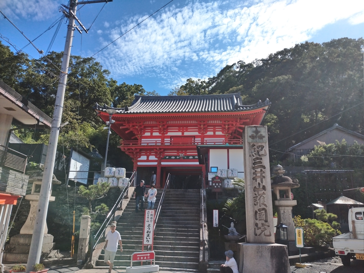
昨日の疲れもあり830発。気温29度。出発するとすぐ道路標識で紀三井寺(きみいでら)の表示。道路標識に大きく書いてあるくらいだから立派な寺のはず。今日は余裕あるので行って見よう。楼門をくぐり急な階段を登る。


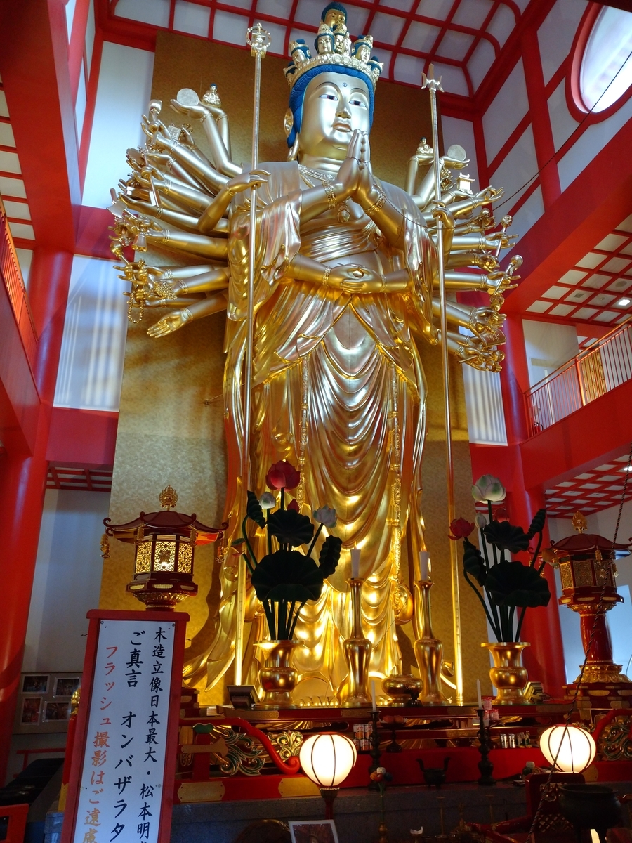
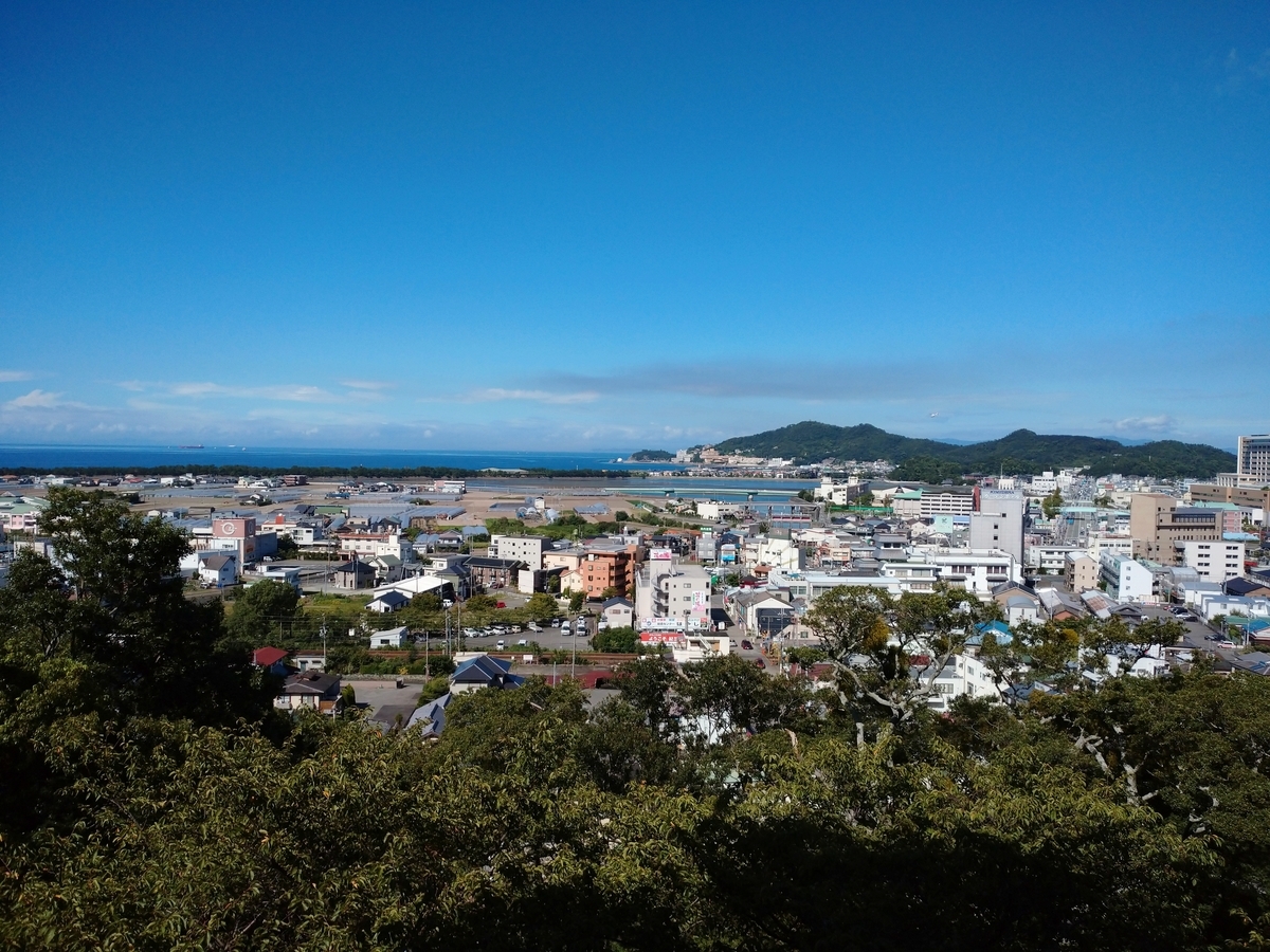
平成20年に建てられた新仏殿の中に、日本最大の黄金に輝く観音様がいらしゃった。心から色々お願いしました。そこから見る海がキラキラしてとてもきれいだった。


そこから印南(いなみ)まで、海あり山ありトンネルありの中々大変な道のり。ミカン産地で有名な有田も通りました。到着前に、オジサンが車を降りて話しかけてきた。「おっ、お接待か!」と思ったら、新興宗教の勧誘だった。疲れている自転車オジサンを勧誘しないでよ!
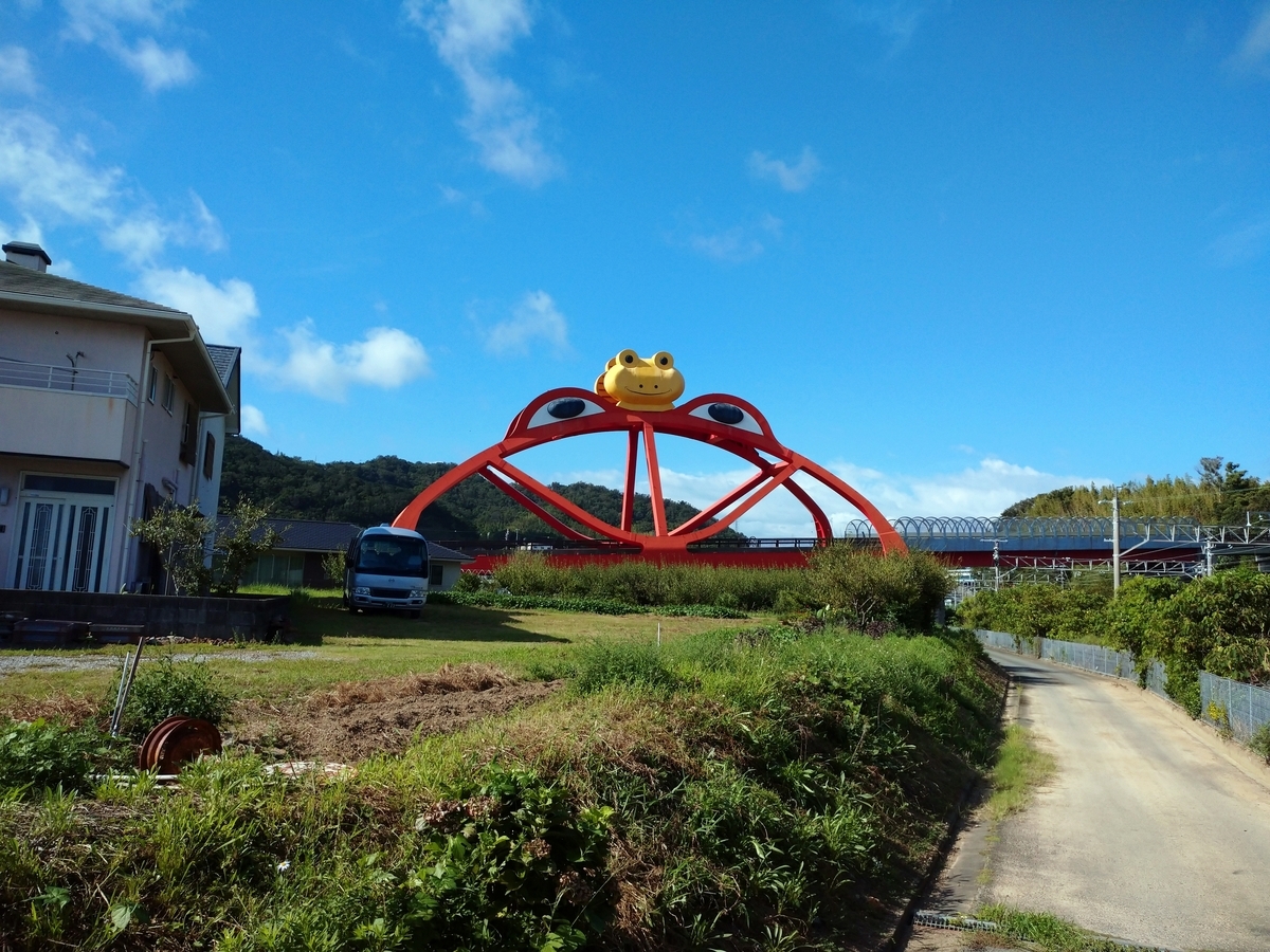
昨日100km越えだったので、寄る年波を考えて80km前後の印南(いなみ)に泊ることにした。その駅のすぐそばに、なんとも風景と場違いな「かえる大橋」があった。


印南町には、「かえる五か条」なるものがある。1)考える、2)人をかえる、3)町をかえる、4)古里にかえる、5)栄えるとの事。勉強になりました。
走行距離:83km、通過トンネル:13
https://latlonglab.yahoo.co.jp/route/watch?id=4de95d4fcf58a2b7b713b0e4fbc7b980
830departure. Temp:29C. As soon as I started, I found the traffic sign “Kimiidera Temple”. I supposed that this temple could be very famous in this area. Let’s go! After I passed the beautiful gate and went up the steep stairs, I found the golden Kannon in the new buddha hall. The view from the temple was also beautiful.
Up to the destination, there were varieties of roads beside the coast, along the river and in the mountains. It was tough today too.
Close to “Inami Station”, there was a very unique shaped bridge, “Frog Bridge”. The town is promoting itself by the frog.
Today’s mileage:83km, tunnels passed:13
Day109(7/Sep/2019) 神戸―和歌山(Kobe-Wakayama)
(English is available after Japanese.)
750発。28度。今日は長丁場だ。黙々と進もう。都会の何車線もある広い道路を横断する時、歩道橋を押して渡らなければならないのは大変。1時間半後に甲子園球場に到着。球場を一周して先に進む。

大阪に入り、ナビに言われるまま進む。突然、橋もないのに「川を渡れ」の指示。「あーー地図が間違っている!」と思い、いろいろ迂回してみるが、ナビはそこに連れて行く。うろうろしていると、他の自転車もそこに進んでいる。よく見ると地下通路みたいなのがある。「あーー関門海峡方式だ!」と理解した。エレベーターで下に降り、川底トンネルで自転車を押して渡るのだ。安治川(あじがわ)トンネルといいます。

さらに進むと、巨大で不格好な体育館みたいなのがある。「何だ?何だ?」と思ったら。それが京セラドーム大阪でした。ここにあったのか。

まだまだ先は長い。目的地までまだ70km程ある。頑張らないと日が暮れてしまう。関空の入り口の泉佐野市は近年「ふるさと納税」で総務省に立てついて有名になったが、税金の無駄遣い巨大ビルがあるのでも有名だった。このビルは大阪府の主導でバブル期に造られた。

いよいよ県境。100m程しかない峠だが、終盤に越えるのはきつい。登りきってやっと和歌山市内へ。紀ノ川が流れている。

ずーっと自転車に乗りっぱなしの一日だった。今日は疲れた。和歌山駅に到着。

地図を見ると、市内には和歌山駅と和歌山市駅がある。混乱しないの?
走行距離:107km、通過トンネル:1
ルートラボ(Route Lab)
https://latlonglab.yahoo.co.jp/route/watch?id=720b186508ecbb6b9da8debcd71439c3
750departure. Temp:28C. It would be a long trip today. I should pedal continuously without rest. After 1.5hours, I arrived “Koshien Baseball Filed”. I moved forward after I went around the field.
In Osaka city, the navigation indicated to cross the river at the place without the bridge. I thought this was a bug of the digital map. When I wondered, I saw several bicycles were going to the place where the navigation showed. I realized that it was an under-river tunnel using an elevator. It was “Ajigawa Tunnel”.
Near to this tunnel, I found a gigantic gymnasium. “What’s this?” It was a baseball field dome, called “Kyosera Osaka Dome”. From here to the destination, more than 70km distance was remained. I should move, otherwise it would be dark today.
I reached Izumisano city at the opposite side of “Kansai International Airport”. In this city, there was a very tall building. This was a famous one as the example of wasting tax money, which was built during the bubble economy period.
After the pass of the prefecture’s border, I entered Wakayama city. I could see Kinokawa river. Today I was exhausted due to the long trip more than 100km. Finally, I arrived Wakayama station.
Today’s mileage;107km, tunnel passed:1
Day108(6/Sep/2019) 姫路―神戸(Himeji-Kobe)
(English is available after Japanese.)
815発。29度。久しぶりの夏の天気。今日は海沿いを神戸まで。殆ど平坦なので軽いもんです。3時間ぐらいで明石に到着。晴れていて、明石海峡大橋が見事です。

吊り橋として世界一の長さ(全長3911m、2本の支柱の間1991m)です。


当初の予定は、ここ明石からフェリーに乗って淡路島経由で再度四国に渡る計画でしたが、四国へ自転車を運ぶサービスが無くなり(橋は渡れない、フェリーもない)、計画変更で今日は神戸まで。神戸駅に到着。

夜は関西在住の高校時代の同級生3人が激励会を開いてくれた。私を含め全員が2年時の同じクラスだった。40年以上たっても風貌が全く変わらないK田君。2学期に転校した麻丘めぐみに似だったE藤さん、今日は少々お疲れ気味だった幹事のスマイルRieちゃん。ありがとうございました。写真はありません!
走行距離:60km、通過トンネル:0
ルートラボ(Route Lab)
https://latlonglab.yahoo.co.jp/route/watch?id=0132533bb5b783cfc46caed3d57c98dd
815departure. Temp:29C. Today was the summer weather. From Himeji to Kobe, the road was along with the coast and flat. It was a easy job. In Akashi city, I could see the beautiful Awaji Channel Bridge. This is the longest(3911m) suspension bridge in the world.
I had been considering moving to Shikoku island via Awaji island (the other side of bridge). However, the transportation service of bicycle from Awaji to Shikoku was already ended. There was no way to carry the bicycle to Shikoku. That was why I moved to Kobe today. I arrived Kobe station.
In the evening, 3 classmates of high school kindly arranged the encouragement-party for me. I met them almost after 30-40 years.
Today’s mileage;60km, tunnel passed:0
Day107(5/Sep/2019) 高松―小豆島―姫路(Takamatsu-Shodo Island-Himeji)
(English is available after Japanese.)
715発。26度。晴れ。今日はまずフェリーに乗って小豆島、土庄港(とのしょうこう。昨日までどしょうみなとだと読んでいたけど)へ向けて出発。ここには行きたかった。なぜか? これです。https://www.youtube.com/watch?v=Hg-pX4MtKZQ 前奏のナレーションがたまらないですね!「ネオン町」があるかなと、ちょっと探したけど、なーーーんにもなかった。
小豆島と言えば、「オリーブの島」。いたるところにオリーブ畑。写真はオリーブ畑を持つ土産物屋さんの施設。買いたいものは色々あったが、荷物になるからトイレだけ借りた。

小豆島では土庄港から反対側の福田港まで28km程を2時間半で行けばいいからラクチンな行程。道も限られているからナビも使う必要なし。1時間ちょっと走ってあと港まで何キロかなー?とチェックすると、道を間違えていた。3kmほど引っ返して正しい道へ。計6kmのロス。ナビによると、このまま走って到着予定時間はフェリー出発の3分前! 乗り遅れたら1時間半待たなければならない。それは嫌だ!それから1時間は全力で頑張りました!「予定通り乗れたら、これからのお前の望みはすべてかなうはずだからヤルンダ!ガンバレ!」と自己暗示にかけながら坂道もひーひー言いながら全く休まず水も飲まず頑張り5分前に到着!間に合った! Day81の鹿児島で指宿行きフェリーに間に合わせるのと同じ経験だった。したがって小豆島の写真はオリーブ園しかない。まあ「私の望みはすべてかなう事になった」ので良しとしよう。
1時間半の船旅で姫路へ。姫路と言えばやはり姫路城でしょう。平成の大改修で「白鷺城」ではなく「白過ぎ城」になったと言われていたが、以前を知らない私には「すばらしい」の一言。優雅、荘厳、可憐、、、、他なんだろうそう気品。とにかく外観はすばらしい。


天守閣に登らなくてもよかったが、まあ入場料に含まれているので登ったらこれまた感動。すべて板張りではないか!江戸時代初期に張られた板張りを歩いているのだ。大きな大黒柱も当時の物。

また昭和の大修理というのが1956年から8年の歳月をかけて行われたことも初めて知った。その大修理では城をすべて解体し、部材を修理して、再度組み立て直したらしい。延べ25万人が関わったとの事。修理をやろうと決定した英断もすばらしい。疑いもなく、世界に誇る日本の宝である。
姫路城の入場料が1000円。隣にある「好古園(こうこえん)」という庭園とセットだと1040円。全く知らない庭園だったがたった40円なので、セットチケットを買いそこにも行って見た。期待していなかったが、これが裏切られた。すばらしい庭園だった。


Day70の足立美術館がアメリカの雑誌が選んだ日本一の庭園かもしれないが、入場料2300円。この好古園は規模こそ小さいがすばらしい庭園だ!それも40円。コスパで考えると、この好古園はすごいの一言だ。庭園の良さはコスパで評価されても良いではないか!
走行距離:46km(短かったが、ひーひー度は高かった)、通過トンネル:1
ルートラボ(Route Lab)
https://latlonglab.yahoo.co.jp/route/watch?id=9d999aeb130f3ea79a3e1f3aec8070ca
715 departure. Temp:26C. Fine day. I would go to Tonosho port in ShodoShima Island. There is a song about this port. That was why I had an interest to go there. The speciality of this island is olive. There are a lot of fields of olive everywhere. Though I just dropped the shop of Olive Park, I didn’t buy anything. Today I had enough time to reach the destination (another port). I should run around 28km for 2hours +.
Since the road was also simple, I didn’t use the navigation. After I run for an hour, I checked where I was. And I realized I was in the wrong road. I should go back around 3km. It meant I lost 6km.
According to the navigation, I would arrive the destination just 3 mins of the departure of ferry boat. For the coming an hour, I pedaled as much as I could. I didn’t get off even at the steep slope. After I spent all energies, I could arrive just 5 mins before the departure.
After 1.5hours journey on the sea, I could arrive Himeji-city. The most famous thing in this city is well-known “Himeji Castle”. This is a national treasure. You can see how this castle is elegant, beautiful and awe-inspiring. All materials of this castle were original around 400 years ago.
Thanks to today’s visit, I knew there was a full-scale renovation 60years ago. The castle was dismantled, all materials were repaired, and they were reconstructed again. It took 8years and around 250k people were involved. This is a real national treasure.
Beside the castle, there was a Japanese garden named “Koko-en”. Although I didn’t expect anything for this garden, I was surprised that it was good. The size was not big but it was really traditional. I liked it.
Today’s mileage:46km, tunnel passed:1
Day106(4/Sep/2019) 四国中央―観音寺―高松(ShikokuChuo-Kannonji-Takamatsu)
(English is available after Japanese.)
805発。26度。今日もお仕事頑張るか!15分ぐらいこぐとすぐ香川県に入った。 入ってすぐ「うどん屋」があったのには笑った。今日はまず観音寺の「寛永通宝」の砂絵を見に行くことにした。40年前自転車旅行で四国に入った時もここを訪れ、感心したものでした。Day53の田舎館村の「田んぼアート」と同じような感じだったはず。下から見ると、まあこんなもんでしょう。何が何やらわからない?

そして高台の展望台に上ると、「あちゃー」陽の光の角度のせいなのか、ただの砂の穴ぼこにしか見えない。本当は下のWEB写真のようにちゃんと見えるんだけどね。


これは1633年、藩主がこの地に巡視に来た際、領民が歓迎の意味を込めて一夜で作りあげたものらしい。現在は春と秋に砂地をきれいにする作業がボランティアによって行われているとの事。
昼になって、やはり「うどん」だろうと混んでいそうなうどん屋へ。小、大、ジャンボというサイズがあったので、「じゃあジャンボ下さい。」と言ったら「やめておきなさい。四玉だよ!」とお姉さんに言われて「大」にした。これで400円。二玉以上はあっただろうな。老若男女で大変混んでいた。さすがうどん県。


丸亀市に入ると、見事に円すい形をした山が現れた。讃岐の人にとっては常識だろうけど飯野山(標高422m)といいます。やはりここも讃岐富士とよばれています。

夕立が今日も来たが、高松駅に到着。予定していたジャイアントショップ高松で、自転車の後輪のタイヤを交換。ありがとうございました。


走行距離;75km、通過トンネル:0
ルートラボ(Route Lab)
https://latlonglab.yahoo.co.jp/route/watch?id=0f774ce387aafc4b48b797a5605449b5
805am departure. Temp:26C. After 15mins, I entered Kagawa prefecture. Immediately I found the Udon noodle restaurant. Kagawa Pref. is very famous for Udon noodle. I moved to Kannonji city to see the sand-art which was made in the year of 1633. Local people made it to entertain the lord who visited this area. Since then, this art has been maintained by the people twice a year. Due to the angle of sunshine, I couldn’t recognize the art well from the observatory. For your understanding, I put the beautifu one from WEB.
For lunch, I went to the Udon restaurant where was very clouded. I ordered the extra-large size to the waitress, but she suggested not to do. It must be too much for me. I changed to the large.
In Marugame city, I found the very delta-cone-shaped mountain. It was beautiful. It must be very famous in this area, but I didn’t know anything. It was Mt. Iino, the height:422m. It was also called as “Sanuki Fuji”.
There was a shower before I arrived Takamatsu station. And as I planned, I went to Giant Takamatsu Shop to replace the rear tire.
Today’s mileage:75km, tunnel passed:0
Day105(3/Sep/2019) 大歩危―祖谷―四国中央(Oboke…Iya-ShikokuChuo)
(English is available after Japanese.)
朝6時ごろ大歩危の川沿いに出てみた。高い山が太陽をさえぎりまだ涼しい。吉野川の水がきれいだ。


友人からの情報で、近くに「祖谷(いや。昨日までそやだと思っていた)のかずら橋」というのがあるらしい。地図で調べると距離では13-14kmほど。しかし、切り立った山をこえなければならない。標高を調べて見ると、大歩危(おおぼけ)が176m、山越えのトンネルが550m、かずら橋が360m。とてもじゃないが自転車では行けない。幸運にも9時前に出て、11時半に帰って来るバスがある。バスの所要時間は片道30分。丁度いい。四国バスはヤマト運輸と協業していた。こうでないと物流のコストと人手不足は補えない! がんばれ日本!

かずら橋に到着。祖谷(いや)川の上にかかっている。想像より低い所にかかっていたが見事である。


歩くところが大きく隙間があるのがいいし、このかずらの太さは尋常じゃない。


下からの眺めもいい。この辺りの祖谷川には大きな花崗岩(?)がごろごろしていて、水も驚くほど透明だ。まさに秘境とはこんな所だ。


近くの物産館で、このかずら橋は鉄のワイヤーで補強されており、ワイヤーにかずらを巻き付けてあると知った。まあそうだろうな。。。しかし、かずらは3年ごとに張り替えられており、最近は直径2cm以上のかずらを探すのが大変になってきているらしい。そこまで成長するには20年かかるらしい。それは大変だ!
大歩危に帰って正午出発。気温27度。少し行くと、小歩危(こぼけ)があり、いくつかの吊り橋がかかっていた。


吉野川が北への流れから大きく東に折れる地点で、私は真逆の西に向かい(ルートラボ参照)、四国中央市へ。これは正面に高い山々がそびえ、西か東に行くしかないからだ。最後に夕立が来た。
走行距離:43km、通過トンネル:3
https://latlonglab.yahoo.co.jp/route/watch?id=dac235ee0c97d8791e85bcf7c7d01b61
Around 600am, I went out and walked around the river side of Oboke. It was still cool thanks to the shade by steep mountains. The water of Yoshino river was clear to the bottom.
I got information from my friend that there was a suspension bridge made of creeping plant in Iya village. I found that the distance was only 13-14km from Oboke. However, in order to reach there, I should go over mountains. According to the altitude map, Oboke was 170m, the highest point on the road was 550m and the destination was 350m. It was impossible to go by bicycle.
There was a bus service and it took 30mins from here. The bus schedule was also very convenient for me. I could depart at 900am and could come back here at 1130. Let’s go! The bus carried the container of other logistic company. This was a cooperation-work by different industries. In Japan, due to the hike of labor cost and the shortage of manpower, it is necessary to find the way of rationalization.
I arrived “Iya Suspension Bridge made of Plant” over Iya river. Although it located at the lower point than my expectation, it was very nice. It was also nice and thrilling that the gap of passageway was wide. The thickness of plant was also unbelievable. According to the information, it takes around 20 years for this plant to grow up to this thickness. Moreover, these plants were changed every 3 years. Therefore, it becomes very difficult to find these materials. The water of Iya river was also extremely transparent.
After I came back and resumed the journey at noon. Temp:27C. I found several suspension bridges over Yoshino river too.
Before I arrived Shikoku Chuou city, I was caught in a sudden shower.
Today’s mileage:43km, tunnels passed:3
Day104(2/Sep/2019) 高知―大歩危(Kochi-Oboke)
(English is available after Japanese.)
朝4時ごろ強い雨の音が聞こえていた。心配しながらうつらうつら。出発をちょっと遅らせた方が良いかも知れないと思い840発。気温27度。日が照っている。暑い。今日は最初からガンガン登りが続く。四国の中央部に向かって突入するから無理もない。登りの道になると登場するのが「登坂車線」の標識。「この先、登坂車線があるよ!」 「ほら、ここから始まるよ!」「もう、終わりだよ!」の三つでワンセット。遅い車は左によけないと、はやりの「あおり」に会うかもしれないから注意。


これまでの経験からこの登坂車線を見ると、「さあ登りのクライマックスだ。これが終わると峠かトンネルがあるはず。その先は下りだ!」とワクワクしたものだが、今日は勝手が違う。この登坂車線セットが五連発続いた。まだかよ! まだかよ! まだかよ!の連続。期待が大きい分だけ、それが叶わなかった時の落胆は大きいものです。しかし五連発は効きました。精神を鍛えられました。二時間登って来てやっと峠。根曳峠(ねびきとうげ)と言います。標高395m。

一昨日苦労した四万十町の峠が230m。その倍近く。「四国の山をなめてはいかんぜよ!」 なめてないですけど。。。
峠を過ぎてトンネルを通って下っていると、「日本一の大杉」看板。有名な?「杉の大杉」というのがあるらしい。「えっ、日本一の大杉は屋久島にある縄文杉じゃないの?」と思いながら行って見る。

推定樹齢3000年。南大杉(周囲20m、樹高60m)と北大杉(周囲16.5m、樹高57m)の二株からなっており、根元でつながっている。


これはDay8に見た「爺杉、婆杉」に似ているではないか。あれは樹齢1200年の小僧でしたが。。。。

これが「日本一の古い大杉」ならもっとPRすべきである。少なくとも「縄文杉」と同じくらいの知名度があってもよさそうなもんだ。「旧石器杉」だと樹齢一万年が必要なのでその名では詐称になってしまう。「超縄文杉」というのではどうだろう?「四国の山をなめてはいかんぜよ!」。
そして、ここには美空ひばりまで登場するのである。彼女が9歳のころ前座歌手としてバスで四国巡業中この大杉の下あたり転落事故。九死に一生を得た彼女は、この大杉に「日本一の歌手になれますように」と願をかけたらしい。この大杉の近くに彼女の遺影碑(こんな言葉あるのかな?)あり、ボタンを押すと歌が流れる。

誰も居なかったので、「川の流れのように」にを押すと、大変音質の良い歌が流れてきた。わざわざ二番まで歌ってくれて、残して去るのも悪い(誰に?)ので所在無げに聞いていました。二番まで聞くのは長い!カラオケは一番だけで充分である!というのが、私の主義主張です。
大歩危(おおぼけ)に着く。標高は確かに170m程だから高くない。実は大歩危に向かって、川(吉野川)は下っていたのです。出発前は当然ここまで登ってくるもんだと思っていた。風景は険しい山奥の秘境そのものです。


このような川の風景では「秩父の長瀞」が有名だが、「大歩危」の前ではひれ伏すしかないでしょう。
走行距離:63km、通過トンネル:4
ルートラボ(Route Lab)
https://latlonglab.yahoo.co.jp/route/watch?id=7c00ed507763a589b45a3dfb546d3521
Around 400am, I could hear the strong sounds of rain. Therefore, I intentionally delayed the departure at 840am. There was a sunshine and the temp:27C. It was hot! From the beginning, the ascent started. In Japan, there are traffic signs near to the pass on the ascent road. The slow lane is added around there, and the sign shows “the slow lane will be started.”, “the slow lane now starts” and “the slow lane ends.”. Those 3 signs are in one-set.
When I saw these signs, I could guess the pass was just around the corner! And I expected that the descent road would be started after the last sign. However, today’s road had 5 sets of these 3 signs consecutively. I was tired to see them.
Finally, after 2 hours ride, I could reach the pass of “Nebiki”. The altitude was 395m. This was much higher than the pass(230m) of the day before yesterday.
After the pass, I also found the sign board, “The Oldest Japanese Cedar in Japan”. All Japanese know that the oldest one (Jomon Cedar) is in Yakushima Island. What is this signboard saying? I tried to check it. There were huge cedars which were connected at the bottom. The tree age was more than 3000years. If this is the oldest in Japan, it is necessary to promote this. Otherwise, no one knows about this tree.
Around this tree, there was a small park and the monument of Japanese famous female singer was there. I could listen to her song after I pushed the bottom,
I arrived Ohboke area, which was the valley surrounded steep mountains. And there were massive rocks of unusual shapes. The pleasure cruisers were also available.
Today’s mileage:63km, tunnels passed:4